
The magnanimity of mapping the Himalayas by a veteran explorer is turning out to be of a great help to trekkers. Difficulties faced in finding a detailed trekking Map of Indian Himalayas is going to be a thing in the past. This gives a good reason for Independent Trekkers in India to rejoice.
The first free version of the downloadable Map got a tremendous response. The anticipated launch of a GPS-aided Mapping software is going to be a game changer for explorers. We investigate.
The scope of exploring the Indian Himalayas
Exploring 500,000 square kilometers of Indian Himalayas is hard to ignore for any adventurer. That is five times the size of the mountainous expanse in Nepal. Quite so there is more to the Himalayas than Nepal.
Nepal’s Example
Nepal has benefited from a strong trekking culture and infrastructure. Thanks to the ever-growing interest of climbing Everest. These pursuits have benefited from modern technological intervention. Years of reconnaissance expeditions have brought forth vital terrain information. Well-researched maps are up to date with GPS data of the trail. It is possible for trekkers to carry the downloadable map in their GPS device for offline use. This has given trekkers precise trail navigation details (altitude, longitude, latitude) of important landmarks.
Problem of finding up to date Navigation Maps of Indian Himalayas
Unfortunately, the high standard of Mapping is missing for the Indian Himalayas. When it comes to relying on mapping the trail, Google Earth is the most preferred tool for trekkers. But the process of rendering a comprehensible map of the Himalayan terrain is tricky. One has to rely on taking print out of the google image of the sector and merge it with other Map Sheets available.
Detailed Survey of India Maps is not available for general public. Trekkers have to rely on topographic maps provided by select few vendors.
Leomann Sheets are the most sort after Sheets available for the Indian Himalayas. Unfortunately, they come in a resolution of 1:20000. This is way less than desired resolution.
Many adventurers rely on Soviet Military Topographic Maps. They come in a resolution of 1:100,000 to 1:200,000. The precise topographic details are impressive. But, a lot of manual data rendering (layering) needs adding.
Read more about the secret inside world of Soviet Map Makers from Cold War era.
The biggest drawback of these Sheets is that they do not come with the up to date GPS fed trail data. There is no way a trekker can know changes in the landscape. The precise location of a rivulet, a bridge, village, campsite keeps changing every season.
What is Himalaya Map Project
Himalaya Maps is a project started by Depi Chaudhry. A veteran outdoor enthusiast is an author to a Trekking Guidebook. Depi chartered a mission of creating detailed trekking maps for trekkers.
The task is complex. It involves stitching together 30,000 images to create a 17×17 feet detailed contour map. The digital rendition is now available for a free download.
Follow updates on the Project on Himalaya Maps Facebook Page
The Mapping Process
The first hurdle was to get all the sheets. Depi ran many errands to get hands on map sheets from various people. He relied on Survey of India, Leomann, and Olizane sheets. But some of them were available for limited sectors of Himalayas.
Depi had a huge task of putting together thousands of scanned images of contour maps. But how to stitch together all the humongous data together?
Luckily Depi heard about an application called Open Cycle Map. The layering software allowed to merge the contour sheets with GPS data. This helped in giving more perspective to the Sheet. The contour trails were no longer one dimensional. A change in elevation was finally showing up.
Stitching the contour sheets together on the layering software took a long time. Depi reworked the trekking trail using the Contour lines and GPS data. Every road, river, bridge, campsite, water source, villages, trekking trail were hand drawn. Depi managed to map 40 treks in the Indian Himalayas using the available GPS data to the master sheet.
What’s next?
In early 2015, Depi unveiled his project at Indian Mountaineering Foundation headquarters in Delhi. A power packed visual presentation was well received.
Depi shared details of his plans of a collaboration with the software giant, TCS. Tata Consultancy Services has partnered with Depi to develop a Mapping application. This is going to be a true crowdsourcing platform for trekkers to update GPS trail data on real time. The end result will be up to date trail maps. The future of mapping endeavor is Digital.
How is Himalaya Maps Project useful for Independent Trekkers?
To put it in perspective, this is the first real attempt for an accurate trekking map in India. It also appears to be the world largest Trekking Map on Indian Himalayas ever compiled. But can such an exhaustive map be useful for independent trekkers? We did a quick assessment.
The Pros
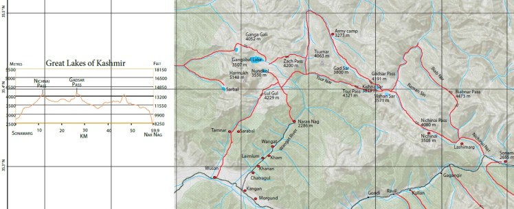
1. We compared one of the popular trail in Kashmir on the Digital Map. The alpine lakes around Harmukh Peak and Sonamarg have many popular trekking trails. It was good to see the inclusion of trails diverge to less frequented routes. Tsur Pass, Lul Ghul, Ganga Gali, Biabnar Pass have clear route marking. Only a handful of people knows about such routes. The GPS elevation Profile helps in knowing cumulative ascent and descent in a day.
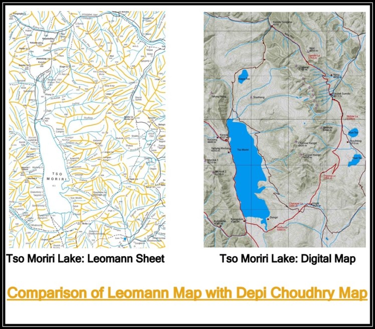
2. We compared Depi’s Map with Leomann Sheet. We took Tso Moriri Lake in Ladakh as a sample. We found Depi’s Map to be more comprehensive and up to date. A few missing roads and mountain Passes on Leomann sheet are in the Digital Map. We also see Depi has taken away a lot of cluttered trails. He has replaced that with real trekking routes. The Map is easy to comprehend.
3. The free Digital Copy of the entire Map is just 30 Mb file size. The PDF format is easy to access on a mobile, tablet, and computer platform. Though we did face a lag when we tried zooming in the Map in a Tablet.
Download the free digital Himalayan Map here
The Cons
1. The Map needs to show more information. Details like camp sites, spring water sources, bridges, streams, river crossings, hamlets are missing. We hope the App version of the Map will have these updates.
2. There are few errors in the name of important landmarks that we saw. They need correction.
3. The Map is only covering the Western Himalayan states of India. We hope the project covers North Eastern Himalayan States as well.
4. Offline Maps for GPS device is missing.
5. There are only 40 Trekking Trails listed in the Map. We hope with the App version, new trails will get populated with user submitted GPS data.
Read More: 5 trusted Trekking Guidebooks on Indian Himalayas
