
Spiti is one destination that is full of beautiful scenery that you’ve probably never laid eyes on — until now. Undaunted we proceed to tell you about one of the most visually stunning location in Spiti very few know about.
“Seek and ye shall find”. The biblical wisdom holds true when a traveler seeks for his next secret destination. For nothing can be more endearing than exploring the unexplored.
How many of us have wondered in getting to a location that gives the best perspective of the place? Balari Top (also known as Palari Top) is the highest vantage point that boasts of an incredible panoramic view of the entire Spiti valley. This is the only location from where you can spot 18 Spitian Villages. A short, two-hour one-way trek (from Demul Village) is all it takes to reach a near 16,250 feet high plateau top. This is one far-fetched location which has remained off the radar of the tourist hustle.

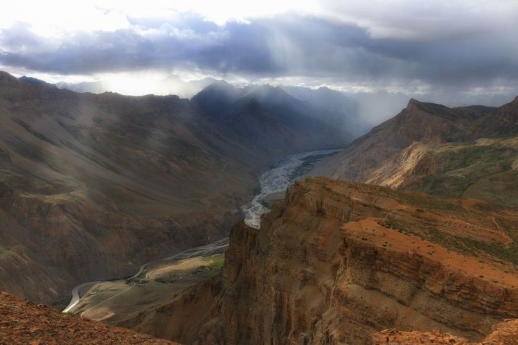
The views from the top are incredible. Looking down gives an astounding view of the Spiti river system as it coils its way through a wide valley. One can see Lingti and Pin rivers merging with Spiti River. The two confluence of these rivers appears like a big congregation of snakes.
If that is not enough, spot a high rising Buddhist Citadel towards the left flank of the confluence of Spiti and Pin rivers. This is the famous Dhankar Monastery. Unbelievable!

Look towards your right side of the valley and retrace the Spiti River all the way to Kaza. Above Kaza you can see its hilltop plateau. Behind this lies the famous green pasture grounds of Langza. Behind Langza you can easily spot the famous Kanamo Peak. Below Kanamo is the old Kibber Village.
Looking back, Demul Village looks sweet. Towering above Demul are the highest snow clad mountain ranges. Towards the extreme left is the famous Chou Chou Kang Nilda Peak followed by Mt. Kuwa and Shilla Pass.
Standing at Balari Top one can absorb Spiti in its entirety. It is the best spot from where one can see, comprehend and appreciate Spiti.
How to do Balari Top Trek

Reach Kaza
For starters, one has to reach Kaza, the administrative headquarter of Spiti District. Kaza can be reached either from Shimla or Manali side. The Manali route is the fastest option. The 202 Km journey takes 12 hours in a local HRTC Bus or 10 hours Jeep ride from Manali.
Kaza to Demul Village
One can either trek (2 days trek) or drive to Demul Village. Demul is now connected via a motorable road. There is no local transport available from Kaza. One can hire a local Jeep from Kaza to Demul.
Click to view list of Taxi drivers contact details in Spiti
Demul can be reached via a 32 km road via Lidang or a longer Hikkim – Komik road. If you start early in the morning, you can trek to Balari Top and return back to Kaza by the evening. Though we advise a night stay at Demul.
Demul to Balari Top Trek

The trek from Demul to Balari Top takes about 3 hours. The gradient is nontechnical but strenuous for beginners. The elevation gain from Demul to Balari Top is approximately 600 meters.
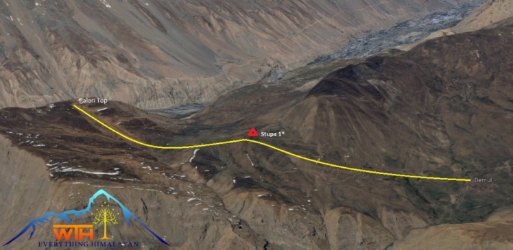
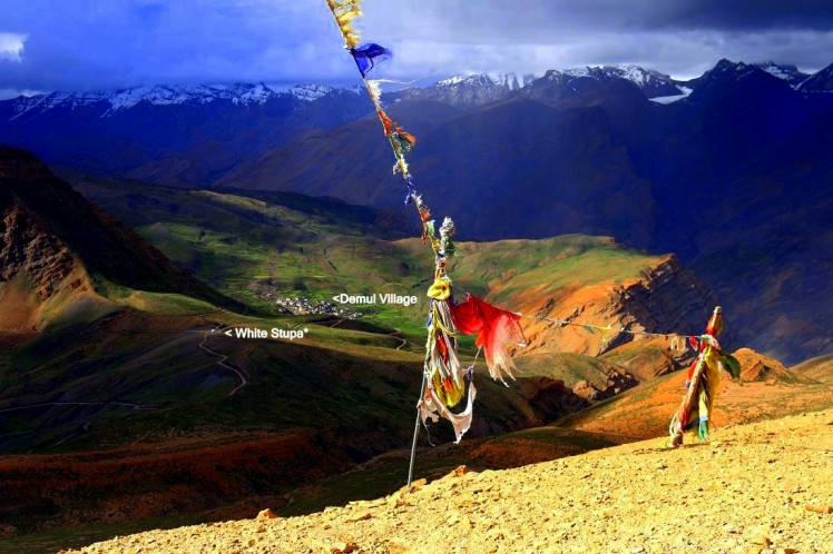
One can shorten this distance by driving till a white Stupa* next to the road head. The Stupa is located at the top of the scissor bend from where one gets to see Demul Village for the first time. From here one has to walk up the ascending ridge. The route is straight forward. It takes about 1 to 2 hour to reach Balari Top.
Photos courtesy of Hiramani Kashyap as our featured Photographer | All permissions obtained.
Any reproduction of this Blog without obtaining a written permission will be subject to copyright violation. Strict Legal action will be taken. You may write to us at wander.the.himalayas@gmail.com for such requests.

Such stunning pics!!!
My plans to spiti and Leh just get cancelled at the end moment everytime and then posts like these make me all sad and desperate! Loved the post 🙂
LikeLiked by 1 person
Thank you. I hope you do visit Spiti soon.
LikeLike
Wonderful pictures nd beautifully summarized in words…brilliant…once in my life I will definately visit spiti…
LikeLike
Thank you Swati.
LikeLike
Vaibhav, in a country where trekking activity is heavily dominated by offerings from trek Agencies, such posts definitely helps to break the trend. I hope people stop looking at trekking as a break which is undertaken once to regular trekking. It’ll be good to see more trekkers than adventure seekers.
LikeLike
Trekking needs to develop as an outdoor pursuit that one must do independently. That there is no need for Trek Agencies to take people on Trek. This requires courage, passion, wisdom to seek for an outdoor life of wilderness, adventure. Sadly doing this requires years of experience, efforts and desire which most people lack. Creating a trekking community catering for these wannabe crowd is not helping. Those who are passionate about exploring the outdoors are doing it quietly while the pretentious lots seek hand holding of the so-called trekking companies.
LikeLiked by 1 person
Right Vaibhav. I’ll agree with you on that since we have been doing solo treks in Aravalis. But I have also realized that there are some peculiar situations which makes people fall back on operators. Heading into wilderness does need some planning and training and there are no resources to fall back on. Having done trek both ways, I don’t see solo trekking growing by leaps and bounds the way trek operators are. It’s true that doing solo ends the “time shackles”; one is free to decide how long one wants to camp and where. That’s what real trekking is. Fortunately, out here we don’t have many people trekking in Aravalis and there are no trails. we enjoy these weekly trip without any bounds. Aravalis are just so beautiful in Monsoon, you should plan a trek here and keep me posted. Hope to make a post on the same soon!
LikeLike
Spiti is on my to-do list. Thanks for your post for the brilliant relevant information.
LikeLike
What a wonderful place.
The light and shadow gives it a good effect.
LikeLike
Interesting piece! I was searching for information on trails in Spiti when I came across this. Just a couple of questions-
1. Will the roads leading to Spiti be open at this point of time, considering the heavy rains and numerous landslides reported across the State (I’m planning to go next week)? Also, would you recommend the Rohtang route or the Kinnaur route?
2. I was initially planning on doing the Spiti Left Bank trail from Komic to Demul, but from whatever little info I could get off the net, it seems that roads have been built over the entire stretch. If this is true, would it still be worth doing the trek? Are there alternative trails? Are there other comparable homestay trails left in in Spiti?
Looking forward to hearing from you. Thanks!
LikeLike
Hi. I will answer your query point wise.
1. The roads are open in Spiti. However, due to the nature of the terrain, landslides/rockfall are common. You may find the road temporary closed for repair,maintenance by BRO. The prime bottleneck areas where this happen is between Kalpa – Puh and Chango to Sumdo stretch. The Kaza – Manali stretch usually have bottleneck area between Batal to Chatru stretch, especially 17 km before Chatru, coming from Batal has 4 major ‘Nallahs’ which are problem areas of vehicles. It is better to do it from Shimla – Kinnaur route. It helps you to acclimatize better. Also, there are no issue of obtaining a permit to cross Rohtang Pass when coming from Kaza to Manali.
2. The trek from Kaza to Demul via Langza – Hikkim – Komic is super. You can stay close to the motorable road so as to not loose sense of direction. For this you would need to spare a few extra days. There are so many trails in that area. For each Village, there are short trails you can take to explore the higher vantage points. Kibber has Tashigong and trail going to Kanamo Peak and Parang La (pass), both requiring proper logistical planning. At Komic you can trek to its higher point and then come down the mountain (from the other side) for an alternative trekking route to Demul. But, my advise is to have a local guide or person along in case you feel like exploring by leaving the road-head. Staying a night at these villages will open lot of opportunities. Home stays are available in every village here. Though they are very basic so expect no luxuries.
LikeLike
Thanks a ton for the information, this is gonna be so helpful!! I think I’ll go ahead with the Kaza to Demul plan then. I would’ve considered Kanamo too but it’s been a year since my last major trek and I haven’t been able to myself in the best of shapes thereafter.
Anyhow, I’m glad to hear that good trails still exist between the high villages and that’s where I’ll be heading to! Much thanks once again for all the help!
LikeLiked by 1 person
It’s beautiful
LikeLike
Yes it is. Thank you 🙂
LikeLiked by 1 person